Archivo de la etiqueta: Inundaciones

Australia toma previsiones frente aumento del nivel del mar

[Visto: 732 veces]

Existe un mapamundi que permite ver que ocurre si se eleva el nivel del mar, uno puede hacer el cálculo tomando como vase 6, 18 y 100 pulgadas (15.24, 45.72, 254 centímetros). De acuerdo con el IPCC podría subir por encima de 30 púlgadas (82 cm).

Con el cálculo del IPCC Australia ha comenzado a tomar algunas previsiones:

20131103-mapa_inundaciones.png

Coast protection costs rise with sea levels 

Anne Davies November 03, 2013
Sydney councils and the state government are facing a multibillion-dollar bill to strengthen and maintain sea walls around the harbour and beaches in the face of rising sea levels.
But despite the threat to low-lying areas, housing densities are increasing in high-risk areas. New developments are being constructed in areas that depend on sea walls around Manly lagoon, at Rushcutters Bay, Double Bay and along the Parramatta River.
If the 82-centimetre rise in the sea level predicted by the Intergovernmental Panel on Climate Change is realised by 2100, coastal developments the length of the NSW coast will be at risk.
In Sydney, the hundreds of kilometres of walls around the harbour will become increasingly vulnerable to stronger wave action in deeper water. These waves can scour out the footings and cause ”overtopping”, when waves slop over a retaining wall and erode it from behind.
The threat comes not just from seawater advancing onto land. Sydney Coastal Councils executive director Geoff Withycombe said higher sea levels are likely to raise the water table and alter the flow of stormwater into the harbour.
This has been a concern during the approval process for the Kiaora Lands development at Double Bay.

Sigue leyendo

CLIMA, MAR Y CONTINENTE

[Visto: 2568 veces]

Siguiendo con mi duda sobre las razones de la crecida del mar en nuestras peruanas costas encontré ayer en un periódico australiano, el Sunday mornig, una noticia (How Australia’s big wet befuddled scientists) sobre los hallazgos de un grupo de científicos de la National Science Foundation sobre el papel de Australia en la dinámica de los océanos. La noticia era formidable, daba cuenta de la relación entre los continentes y el mar.

20131020-rainfall-spring-2010-australia3.gif

Inundaciones en Australia 2010-2011

Australia es un sumidero que atrae tanta humedad en determinados periodos que el nivel del mar puede disminuir hasta 7 mm, más de lo que aumenta por efecto del calentamiento global cada año (3,2mm en promedio). Uno de estos periodos fue entre 2010 y 2011.

20130820-sea2b-620x349.jpg

Australia funciona como una enorme esponja que retiene agua y la exuda, a veces en catastróficas formas.

Este fenómeno parce además reforzarse cuando hay Niña que trae aguas frías que enfrentadas al calor atmosférico llevan el vapor al continente. Hay que tener en cuenta además que en el periodo mencionado La Niña afectó Australia dos años de manera consecutiva, siendo uno de ellos el más fuerte de la historia.

“Los investigadores estadounidenses dijeron topografía única de Australia y la falta de escorrentía fluvial al oeste de la Gran Cordillera Divisoria fueron clave para el impacto en los niveles globales del mar.”

Esto que parece un buen noticia parece sin embargo se  un hipo en una tendencia al aumento en el nivel del mar. De acuerdo con un informe sobre el cambio climático esto sucederá a una velocidad mayor en los años que vienen. Los científicos esperan ahora que los mares se elevarán entre 290 y 820 milímetros para el final del siglo, a partir de un rango de pronóstico anterior de 180 a 590 milímetros.

Pero, tiene todo esto algo que ver con lo que pasa en nuestras costas. Es posible. Después de todo este es un año de crecimiento del mar. Australia está sufriendo una sequía y La Niña se pasó a nuestras costas lo que hace de nuestro invierno algo más frío y húmedo que de costumbre, pero dada nuestra topografía no jugamos el mismo papel que Australia. Para nosotros es buena época para recuperar algo de nieve, reducir las escorrentías de los glaciares, y aumentar las lluvias en el sur (cosa que debe ocurrir en los meses que vienen), y que en algunas ocasiones se tornan en inundaciones.

20130820-bolivia_al_sur_del_lago.jpg

Rastros de civilización prehispánica al sur del lago Titicaca

De otra parte los científicos no hacen más que confirmar que el nivel del mar aumenta, afectando nuestra línea de costa que se dibujará de diferentes maneras una y otra vez, pero siempre con pérdida de superficie.

Sigue leyendo

Sube la marea, calienta el sol

[Visto: 1115 veces]

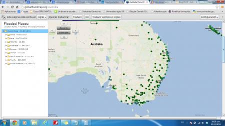
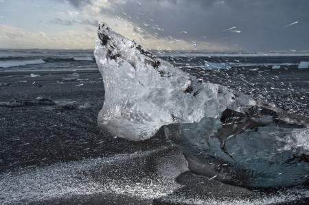
Mientras los gobiernos reunidos en Qatar (COP 18) retrasan las acciones para enfrentar el calentamiento global, los hielos se derriten y las aguas del mar avanzan sobre las tierras bajas. Y esto, también ocurre en el Perú, basta leer con más cuidado las noticias de los problemas de pérdida de playas en Trujillo y Máncora.

Este es un artículo de The Guardian sobre lo que está ocurriendo en las costas de Estados Unidos de Norteamérica.

US coastal cities in danger as sea levels rise faster than expected, study warns

20121128-eis_18.jpg James Balog

Satellite measurements show flooding from storms like Sandy will put low-lying population centres at risk sooner than projected
Suzanne Goldenberg, US environment correspondent

Sea-level rise is occurring much faster than scientists expected – exposing millions more Americans to the destructive floods produced by future Sandy-like storms, new research suggests.

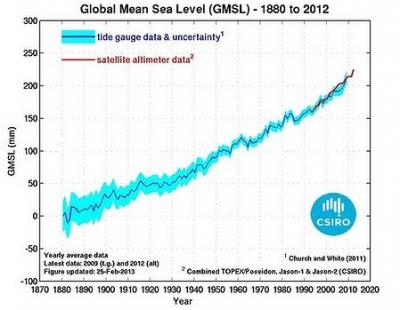
Satellite measurements over the last two decades found global sea levels rising 60% faster than the computer projections issued only a few years ago by the United Nations’ Intergovernmental Panel on Climate Change.

The faster sea-level rise means the authorities will have to take even more ambitious measures to protect low-lying population centres – such as New York City, Los Angeles or Jacksonville, Florida – or risk exposing millions more people to a destructive combination of storm surges on top of sea-level rise, scientists said.

Scientists earlier this year found sea-level rise had already doubled the annual risk of historic flooding across a widespread area of the United States.

The latest research, published on Wednesday in Environmental Research Letters, found global sea-levels rising at a rate of 3.2mm a year, compared to the best estimates by the IPCC of 2mm a year, or 60% faster.

Researchers used satellite data to measure sea-level rise from 1993-2011. Satellites are much more accurate than tide gauges, the study said.

The scientists said they had ruled out other non-climatic causes for the rise in water levels – and that their study demonstrated that researchers had under-estimated the effects of climate change.

“Generally people are coming around to the opinion that this is going to be far worse than the IPCC projections indicate,” said Grant Foster, a US-based mathematician who worked on the paper with German climatologist Stefan Rahmstorf.

The implications are serious – especially for coastal areas of the US. Large portions of America’s Atlantic and Pacific coasts are regarded as “hotspots” for sea-level rise, with water levels increasing at twice the rate of most other places on the planet.

Scientists previously had expected a global sea-level rise of 1m by the end of the century. “But I would say that if you took a poll among the real experts these days probably they would say that a more realistic figure would be more than that,” Foster said.

“The study indicates that this is going to be as bad or worse than the worst case scenarios of the IPCC so whatever you were planning from Cape Hatteras to Cape Cod in terms of how you were preparing for sea-level rise – if you thought you had enough defences in place, you probably need more,” Foster said.

A study published last March by Climate Central found sea-level rise due to global warming had already doubled the risk of extreme flood events – so-called once in a century floods – for dozens of locations up and down the Atlantic and Pacific coasts.

It singled out the California cities of Los Angeles and San Diego on the Pacific coast and Jacksonville, Florida, and Savannah, Georgia, on the Atlantic, as the most vulnerable to historic flooding due to sea-level rise.

Sandy, which produced a 9ft storm surge at Battery Park in New York City, produced one example of the dangerous combination of storm surges and rising sea level. In New York, each additional foot of water puts up to 100,000 additional people at risk, according to a map published with the study.

But tens of millions of people are potentially at risk across the country. The same report noted that more than half of the population, in some 285 US cities and towns, lived less than 1m above the high tide mark.

“In some places it takes only a few inches of sea-level rise to convert a once in a century storm to a once in a decade storm,” said Ben Strauss, who directs the sea-level rise programme at Climate Central.

Large swathes of the mid-Atlantic coast, from Virginia through New Jersey, also faced elevated risk of severe flooding, because of climate change, he said.

Sigue leyendo