Qatar
Un país cuya existencia se confunde con una enorme compañía petrolera que seca los pozos aportando tal vez el más alto per cápita de CO2 del planeta.
Qatar
Un lugar donde la gente se viste con finas y frescas túnicas y donde las mujeres no pueden mostrar sus cuerpos ni manejar automóvil.
Qatar
Un gran centro comercial de lujuriosa riqueza que más tarde, o más temprano devorará el desierto.
Qatar
Un centro de convenciones con aire acondicionado y agua traída de París en el que se habla sobre como el calor está transformando el mundo y no hay nada que hacer.
Sigue leyendo
Archivo por meses: noviembre 2012
Sube la marea, calienta el sol
Mientras los gobiernos reunidos en Qatar (COP 18) retrasan las acciones para enfrentar el calentamiento global, los hielos se derriten y las aguas del mar avanzan sobre las tierras bajas. Y esto, también ocurre en el Perú, basta leer con más cuidado las noticias de los problemas de pérdida de playas en Trujillo y Máncora.
Este es un artículo de The Guardian sobre lo que está ocurriendo en las costas de Estados Unidos de Norteamérica.
US coastal cities in danger as sea levels rise faster than expected, study warns
 James Balog
Satellite measurements show flooding from storms like Sandy will put low-lying population centres at risk sooner than projected
Suzanne Goldenberg, US environment correspondent
Sea-level rise is occurring much faster than scientists expected – exposing millions more Americans to the destructive floods produced by future Sandy-like storms, new research suggests.
Satellite measurements over the last two decades found global sea levels rising 60% faster than the computer projections issued only a few years ago by the United Nations’ Intergovernmental Panel on Climate Change.
The faster sea-level rise means the authorities will have to take even more ambitious measures to protect low-lying population centres – such as New York City, Los Angeles or Jacksonville, Florida – or risk exposing millions more people to a destructive combination of storm surges on top of sea-level rise, scientists said.
Scientists earlier this year found sea-level rise had already doubled the annual risk of historic flooding across a widespread area of the United States.
The latest research, published on Wednesday in Environmental Research Letters, found global sea-levels rising at a rate of 3.2mm a year, compared to the best estimates by the IPCC of 2mm a year, or 60% faster.
Researchers used satellite data to measure sea-level rise from 1993-2011. Satellites are much more accurate than tide gauges, the study said.
The scientists said they had ruled out other non-climatic causes for the rise in water levels – and that their study demonstrated that researchers had under-estimated the effects of climate change.
“Generally people are coming around to the opinion that this is going to be far worse than the IPCC projections indicate,” said Grant Foster, a US-based mathematician who worked on the paper with German climatologist Stefan Rahmstorf.
The implications are serious – especially for coastal areas of the US. Large portions of America’s Atlantic and Pacific coasts are regarded as “hotspots” for sea-level rise, with water levels increasing at twice the rate of most other places on the planet.
Scientists previously had expected a global sea-level rise of 1m by the end of the century. “But I would say that if you took a poll among the real experts these days probably they would say that a more realistic figure would be more than that,” Foster said.
“The study indicates that this is going to be as bad or worse than the worst case scenarios of the IPCC so whatever you were planning from Cape Hatteras to Cape Cod in terms of how you were preparing for sea-level rise – if you thought you had enough defences in place, you probably need more,” Foster said.
A study published last March by Climate Central found sea-level rise due to global warming had already doubled the risk of extreme flood events – so-called once in a century floods – for dozens of locations up and down the Atlantic and Pacific coasts.
It singled out the California cities of Los Angeles and San Diego on the Pacific coast and Jacksonville, Florida, and Savannah, Georgia, on the Atlantic, as the most vulnerable to historic flooding due to sea-level rise.
Sandy, which produced a 9ft storm surge at Battery Park in New York City, produced one example of the dangerous combination of storm surges and rising sea level. In New York, each additional foot of water puts up to 100,000 additional people at risk, according to a map published with the study.
But tens of millions of people are potentially at risk across the country. The same report noted that more than half of the population, in some 285 US cities and towns, lived less than 1m above the high tide mark.
“In some places it takes only a few inches of sea-level rise to convert a once in a century storm to a once in a decade storm,” said Ben Strauss, who directs the sea-level rise programme at Climate Central.
Large swathes of the mid-Atlantic coast, from Virginia through New Jersey, also faced elevated risk of severe flooding, because of climate change, he said.
Iron Dumping In The Pacific Ocean Stirs Controversy Over Geoengineering
Este artículo del Hufftington Post aporata algunasideas al debate sobre el controversial tema de la geoingeniería. En este caso el objetivo es recuperar la presncia del salmón en las costas occidentales de Canadá, sin embargo el experimento tiene implicancias mayores si se lo ve como una forma de capturar CO2 de la atmósfera.
From Stephanie Pappas, LiveScience Senior Writer:
A controversial experiment in which more than 200,000 pounds of iron sulfate were dumped into the Pacific Ocean west of Canada has scientists calling for more transparency in geoengineering.
Geoengineering is any deliberate and large-scale manipulation of environmental processes in order to impact Earth’s climate. Some geoengineering projects, like the recent one, can have other impacts like boosting fish populations.

The project was conducted by a local group, the Haida Salmon Restoration Corporation, under the scientific advice of American businessman Russ George, formerly the CEO of a company called Planktos, Inc. The goal, according to Haida Salmon Restoration Corporation, was to trigger plankton blooms to restore salmon and other fish populations. Phytoplankton, teensy floating plants at the base of the ocean food chain, need iron to grow.
Similar ocean-fertilization schemes have been proposed as a way to lessen climate change, as phytoplankton take up carbon dioxide on the ocean’s surface and sink to the bottom, removing carbon from the atmosphere.
This geoengineered approach to solving climate change is controversial, but even researchers who think it has promise said the Canadian experiment went about it the wrong way.
“It should have been done by a group of neutral scientists,” said Victor Smetacek, a researcher at the Alfred Wegener Institute in Germany who conducted a small-scale ocean-fertilization experiment in 2009. Smetacek added, “The thing is, it’s going to give iron fertilization a bad name.”
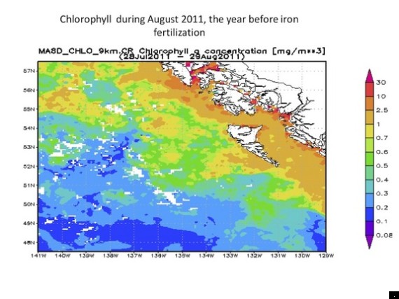
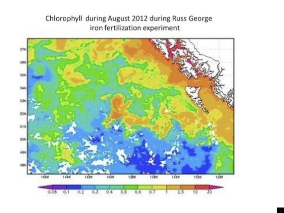
Chlorophyll levels off Canada’s west coast in August, 2011, before the controversial fertilization project. This Giovanni data portal provides standard and evaluation ocean color radiometric data products from SeaWiFS and MODIS. These data products are in support of the NASA Water Quality for Coastal and Inland Waters project, and the National Oceanographic and Atmospheric Administration
